
Showing posts with label Places - Montana. Show all posts
Showing posts with label Places - Montana. Show all posts
Thursday, November 8, 2012
Western Larch - Larix occidentalis, Fall in the Bitterroot Mountains
Click on the photos to "buy" online.


Wednesday, June 13, 2012
"Short-eared Owl " by amontanaview | RedBubble
"Short-eared Owl " by amontanaview | RedBubble: 
Short-eared Owl – Asio flammeus. Taken in a wetlands management area (protected) of the Mission Valley in western Montana, USA. This owl is a year round resident of Montana and prefers to live and hunt in open grasslands, even agricultural areas like this. It is one of the most widely distributed owls in the world. A medium sized owl averaging 15 inches in length, it is the most diurnal of owls often hunting during the day. I think it was posing for me; the eyes mesmerized me and my camera.
Canon EOS 7D, Canon EF500mm f/4L IS USM lens
1/640s, f/8.0, ISO: 250, 500mm, lens hand held (would have used a tripod but didn’t have time to set it up)
Short-eared Owl – Asio flammeus. Taken in a wetlands management area (protected) of the Mission Valley in western Montana, USA. This owl is a year round resident of Montana and prefers to live and hunt in open grasslands, even agricultural areas like this. It is one of the most widely distributed owls in the world. A medium sized owl averaging 15 inches in length, it is the most diurnal of owls often hunting during the day. I think it was posing for me; the eyes mesmerized me and my camera.
Canon EOS 7D, Canon EF500mm f/4L IS USM lens
1/640s, f/8.0, ISO: 250, 500mm, lens hand held (would have used a tripod but didn’t have time to set it up)
Monday, May 7, 2012
"Big wood in the Bitterroot River" by amontanaview | RedBubble
"Big wood in the Bitterroot River" by amontanaview | RedBubble: 
Taken north of Victor, Montana USA in April. One of the features of this beautiful freestone river is the “big wood” that supplies features and cover for wild trout. This is a downed cottonwood tree. We were enjoying another relaxing day on the river and fly fishing.
Taken north of Victor, Montana USA in April. One of the features of this beautiful freestone river is the “big wood” that supplies features and cover for wild trout. This is a downed cottonwood tree. We were enjoying another relaxing day on the river and fly fishing.
Monday, March 26, 2012
One of my favorite Bitterroot River slideshows
Jack, John Hickman, Freda and I fished the lower Bitterroot on Sunday. Quiet, beautiful day and the fishing was great, too.
Monday, December 12, 2011
"Freda, a Chesapeake hunting for bass" by amontanaview | RedBubble
"Freda, a Chesapeake hunting for bass" by amontanaview | RedBubble: 
Featured again on RedBubble. This time in the group "For the love of dogs."
At the time of this photo Freda is a 1 1/2 year old female Chessy. In this photo, she is hunting for bass on the Flathead River in western Montana a few miles south of Buffalo Bridge. I am not sure if you would call this a “point” but maybe…
Shot with Canon 7D, 1/400s, f/7.1, ISO 800
Featured again on RedBubble. This time in the group "For the love of dogs."
At the time of this photo Freda is a 1 1/2 year old female Chessy. In this photo, she is hunting for bass on the Flathead River in western Montana a few miles south of Buffalo Bridge. I am not sure if you would call this a “point” but maybe…
Shot with Canon 7D, 1/400s, f/7.1, ISO 800
Friday, November 11, 2011
"Virga over the Clark Fork River" by amontanaview | RedBubble
"Virga over the Clark Fork River" by amontanaview | RedBubble: 
This was taken April 9, 2011 west of Missoula, Montana USA on the Clark Fork River. The camera is looking north and east at Montana Snowbowl Ski Area and the Rattlesnake Wilderness Area. It was a gorgeous spring day and the fishing was good.
Virga is precipitation that falls from a cloud but evaporates before reaching the ground.
Canon EOS 7D, 1/500s, f/10.0, ISO:200, 39mm
SIGMA 24-70mm f/2.8 EX DG Aspherical DF Macro SLD Autofocus Lens
This photo is featured in:
This was taken April 9, 2011 west of Missoula, Montana USA on the Clark Fork River. The camera is looking north and east at Montana Snowbowl Ski Area and the Rattlesnake Wilderness Area. It was a gorgeous spring day and the fishing was good.
Virga is precipitation that falls from a cloud but evaporates before reaching the ground.
Canon EOS 7D, 1/500s, f/10.0, ISO:200, 39mm
SIGMA 24-70mm f/2.8 EX DG Aspherical DF Macro SLD Autofocus Lens
This photo is featured in:
"Montana Nature Calendar" Calendars by amontanaview | RedBubble
Wednesday, November 9, 2011

Tuesday, November 8, 2011
"Montana Nature Calendar" Calendars by amontanaview | RedBubble
Visit Montana all year long with your Montana Nature Calendar "Montana Nature Calendar" Calendars by amontanaview | RedBubble: 
Friday, October 7, 2011

Saturday, September 26, 2009
Fall colors, fall fishing and more on the Bitterroot River in Montana

Reflections of the sky and fall leaves. Photo: Merle Ann Loman
Click Fall colors, fall fishing and more on the Bitterroot River in Montana for the article on Examiner.com
Fall is a great time to fish the Bitterroot River with the pleasant daytime temperatures cooling from hot summer days of August to the pleasant 70 degree range. The nights drop to 30 or 40 degrees and bring on the gorgeous colors of fall.
Seasonal changes from summer to fall also bring explosions of mayfly hatches such as trico, blue-winged olive, fall drake, and mahogany dun as well as the October caddis.You can expect to see surface feeding fish that will test the resolve of even the most accomplished anglers.
Erosion from spring run-off, or high water events, is a process where new habitat is created or perhaps eliminated. Logs that have been eroded from the banks and deposited somewhere along the channel form the classic Bitterroot holding water. They provide the necessary cover for daily survival and the shade to stay hidden in the heat of a summer day. The Bitterroot is home to a thriving beaver population which can aid in the creation of more new log buckets for the fish. In September, the leaves are on the trees and dropping on the water providing cover but the colors are changing from green to yellows, coppers, reds, and more.

A beautiful brown trout from the Bitterroot River. Photo: Merle Ann Loman
Many tributaries of the Bitterroot River headwaters originate in wilderness areas giving the main river a supply of pristine water up until late July. The West Fork, its main tributary has a dam which releases cold, clean water during the critical times of summer and early fall. The fisheries are a beneficiary of these enhanced flows as is the rancher who can grow his hay crop. Finding a balance between the needs of a fishery and human activities has been an ongoing contentious issue as demands for these cold water releases are increasing. Fortunately, the Bitterroot River fish have an in-stream flow reservation of water. The trout have been given a little consideration.
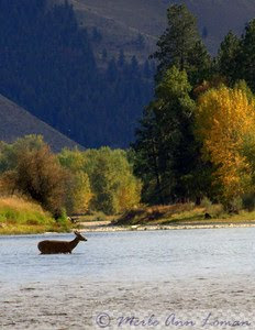
Deer crossing the Bitterroot. Photo: Merle Ann Loman
Despite increased recreational pressure which not only includes fishing but also boating, tubing, and swimming, the Bitterroot River seems to be thriving and still produces good numbers of westslope cutthroat, some brown and rainbow trout as well as the cuttbow, a hybrid between cutthroat and rainbow trout. Catch and release sections have been a big help as is the in-stream flow reservations. The Bitterroot River in Montana is a favorite fall fishing choice for beauty and a variety of fishing.
For more info:
Wapiti Waters Fly Fishing Montana - Bitterroot webpage
Wapiti Waters Fly Fishing Montana - Seasonal hatch information
Montana Fish, Wildlife and Parks - Bitterroot webpage
West Fly Entomology
Wapiti Waters Fly Fishing Montana - Seasonal hatch information
Montana Fish, Wildlife and Parks - Bitterroot webpage
West Fly Entomology
Related Articles:
Fall colors are coming to the Bitterroot Valley in Montana
More photos:
Merle's SmugMug photo site: Bitterroot River in the fall
Monday, September 21, 2009
The Kootenai Creek Fire in the Bitteroot Valley
 The Kootenai Fire started west of Stevensville, Montana on July 12, 2009. Lightning struck in the Kootenai Canyon on a steep rock face about 2 miles into the wilderness. The Bitterroot Valley has had few fires compared to years past, yet this is the one that wouldn't go away.
On August 5, it was about 2000 acres. On August 31 it grew to near 2685 acres still burning mostly in a rocky avalanche shoot with some brush and timber including Lodgepole Pine, Sub-Alpine Fir and Whitebark Pine.
On Saturday, September 19, the strong winds caused it to "blow up" to over 4400 acres and send embers to drainages north and south. Spot fires resulted and now that there was more timber for fuel, smoke began to tumble out and into the valley. Highway 93 near Stevensville had very low visibility for a few days but is better now.
On Sunday, September 20, it was significantly less active. Modest growth occured around much of the fire's perimeter, and fire managers estimate Sunday's growth to be 100 acres, for a total of 4535 acres.
Until Sunday, Forest officials had used helicopter water drops and only a few ground firefighters because the fire was burning on steep slopes in conditions that were too risky and private property was not immediately threatened. Those conditions changed and more resources were ordered.
Firefighting resources arrived at the fire throughout the day on Sunday. Dozers working with Hotshot and Initial Attack crews established 7 miles of dozer and hand-dug indirect fire lines from Bass Creek across and through Kootenai, Larson, and Sharrott drainages connecting to the Forest Service Road #739 in St. Mary's drainage.
Mike Fritsen's Type III Incident Command Team was briefed by Forest officials late Sunday afternoon and has taken over management of the fire as of Monday.
The Bass Creek, Kootenai Creek and Sharrott Creek drainages and the road and trail system in the St. Mary's drainage remain closed to public use to protect public safety and to reduce traffic on the road systems while firefighters are active in the area. The Stage 1 Pre-evacuation Alert & Warning remains in effect for homeowners west of the Sharrott Hill Loop at the west end of the South and Middle Kootenai Creek Roads. No evacuations have been ordered at this time.
Sunday was much cooler but dryer, warmer and less windy weather is predicted for the remainder of the week.
Residents in the possible evacuation zones have had an outpouring of help from the community especially to help transport and board horses and other animals. A resource for dogs, cats and barnyard livestock as space allows is the Bitterroot Humane Society. For horses, the Willing Servants which saw its start with a high-profile equine abuse case, is there to help.
Many people have voiced dismay at not "putting it out" especially at town meetings, yet residents affected feel that the Forest Service is doing a good job and, with the new resources, will get control of the fire soon. Most have moved livestock, are packed and ready to go yet hoping they won't have to.
Log on to RavalliRepublic.com to read other stories and comment if you choose.
To see all the photos in a new window click Merle's SmugMug Kootenai Fire Photos.
Subscribe to:
Posts (Atom)